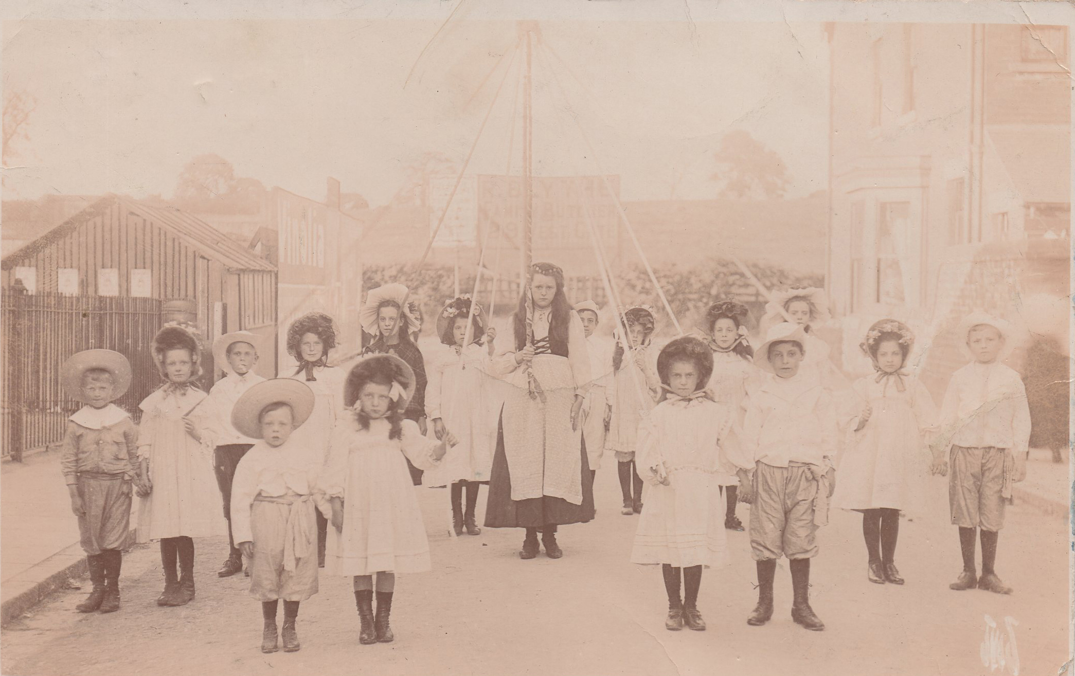
I am trying to identify the location of this Mansfield postcard which has a postmark 1908. The advertisement board at the back says R.Blythe. Family Butcher. 29 Westgate.He is listed at that address in the traders directory from 1899 to 1923+.– I think the photo may have been taken from the Newgate Lane area as the contour of the background fits with the field now known as Jacksons Field, there was a temporary school on Newgate Lane in the 1890s between Heywood Street and Sandy Lane which may be the reason the children are there. The photo was taken between 1899 and 1908. A clearer copy may show Rock Farm at the top left.


Comments about this page
I have checked the 1910 valuation survey and Blythes occupied a 4 acre field on Chesterfield Road which explains the advertisement bilboard.The mystery is solved thanks to Darren Turner
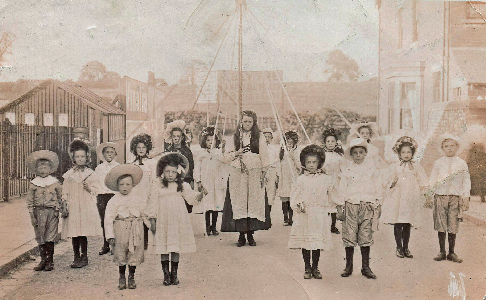
I withdraw my comment of the 7th regarding the suspected alterations. Since seeing Darren Turners ‘Comparison’ I’m now able to see I misjudged the position of the door and windows. Credit must go to Darren for a job well done, not only in locating the mystery junction but also in creating the 2 picture old/new comparison. See Mystery Photo 1908 – Comparison.
I have now submitted a comparison montage photo, showing how how I believe two relate. See Mystery Photo 1908 – Comparison.
Having studied the building more closely I conclude that either some very serious and meticulous structural alterations have been carried out on it or the location is wrong. The row of buildings, (of which our mystery building may be part,) along Chesterfield Road seems to have been built in two stages. On the southern end, some six doors away, stands what was a Co-operative branch that I believe opened in 1904. It would be nice if we could get a date for the chapel building/opening.
The house does seem to fit. If the theory is correct that narrows the date down as the first tram to run along Chesterfield Road to Pleasley left Mansfield Market Place on July 11th 1905 and there is no overhead rigging shown on the picture. It would have taken some months to install the tracks and overhead rigging so that puts the date of the picture between 1899 and 1904. A visit to Nottingham Archives Office to check the 1910 Government Valuation Survey would reveal whether Richard Blythe was the owner or occupier of the field at the back on which his advertising billboard is located and maybe the tin hut may also be shown.
Well Darren, I’m pleased someone has come up with a possible answer, like you, I’ve been troubled by this picture ever since it appeared here and despite a thorough old map search I’ve been unable to come up with anything close. I admit that whilst I checked the other end of Brownlow Rd I’d dismissed Chesterfield Rd end on account of the tram route passing by. Given the section/length of what might/could be Chesterfield Rd shown in the picture I’d have thought a tram pole would be visible. However, I like what you suggest. The chapel, the children, their position in the road (near what could be the chapel gates), the rising ground in the background, the wall near right, it all looks good. What I’m not too convinced by is the many alterations / window portals moved that seem to have been done on the house. Evidence of these changes is not obvious from the Google views. But, despite this, I think you may have cracked it!
I think you could be right Darren. I’ve studied the place you mention at the end of Brownlow Rd on google earth and it does look very much like the building in the photo. It would also be interesting to know what the event was. It looks like a maypole?
I think I may have the answer, although it is quite a way off from where first suggested. Take a look at the Chesterfield Road end of Brownlow Road. The house on the right could, I am sure, be the gable end of the New Garden Chinese Take Away. Chesterfield Road itself (much narrower than today) must pass left to right across the image along the line of the hedge. The hill opposite is the site of Perlethorpe Avenue. The structures and gates to the left would belong to the primitive methodist chapel. The buildings in this location all date back to the early 1900s so would tally with a date of no later than 1908. Perhaps Mr Blythe farmed the land or kept cattle there, in relation to his business as a butcher? Hope you think I’m on to something here. The mystery has been bugging me all over Christmas!!!
Add a comment about this page