I’ve often seen this ‘Pumping Engine’ shown on old maps, now we know!
By Berisford Jones (11/08/2012)
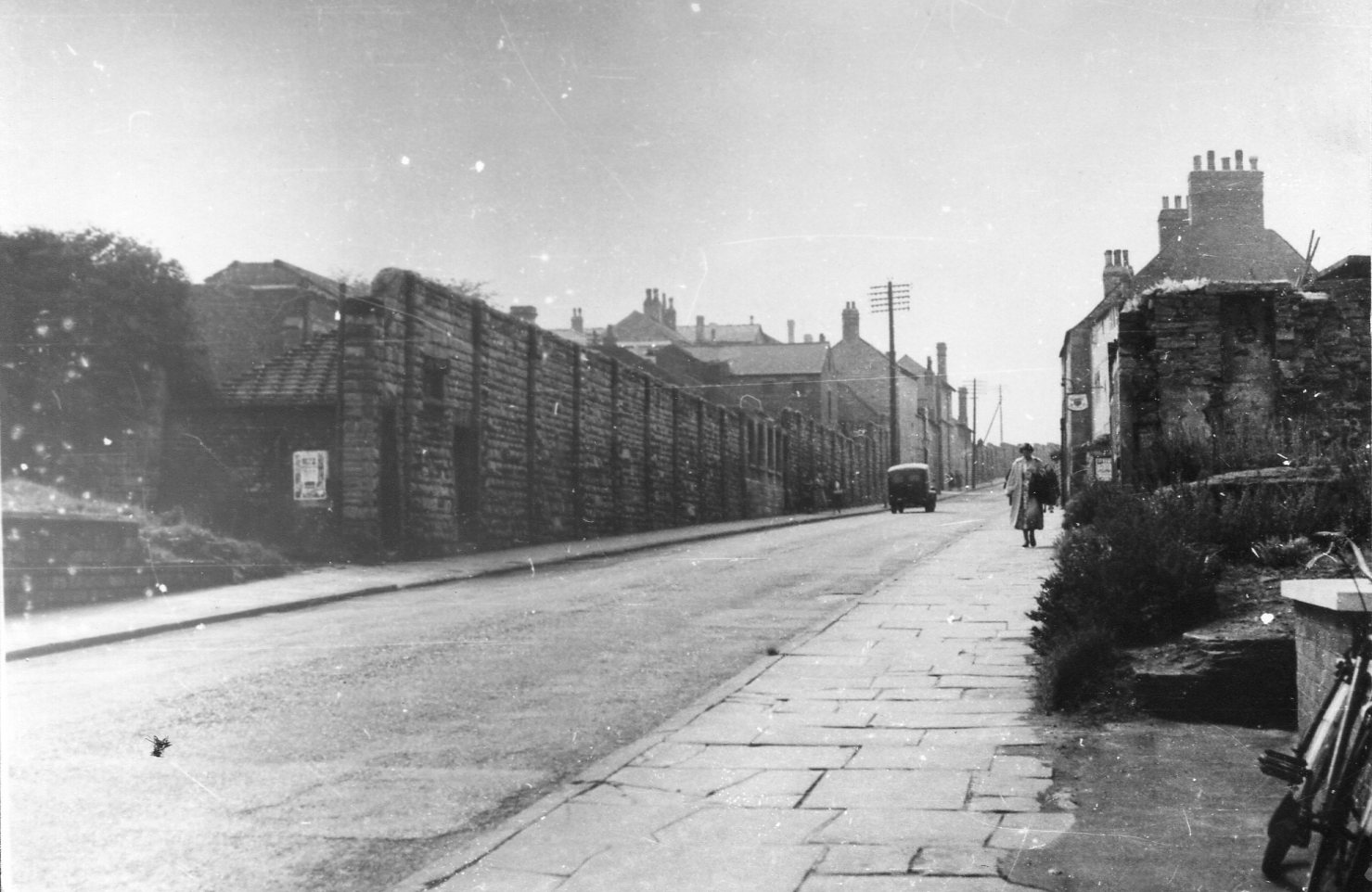
photo no 3 is a old pumping station alongside the old mansfield to pinxton railway line.I dont know when it was last used but was behind houses on millersdale avenue , about half way along.New houses have been built on the site now and the pipes could have been a new drain being installed.
By keith wright (09/08/2012)
Photograph 2…Although quite similar, I agree that the bridge is at the top of Littleworth…. Photograph 4…I remember that I was pushing a wheelbarrow home along this road. which I had purchased from Hameyer and Copelands…When a Co-op Shire Horse, which had been spooked, bolted down Sutton Road at full gallop, complete with Dray and milk crates, but no driver. It flew past, and I have often wondered what happened to it, and how it came to a halt ! This was in the 1950’s. Alan
By alan curtis (03/03/2012)
Alan, Berisford, you’re absolutely right on image 4. There’s a photograph on the Picture the Past (image number NCCW001834) that shows the same view from slightly closer into town showing clearly the Bancroft Lane sign.
By Darren Turner (02/03/2012)
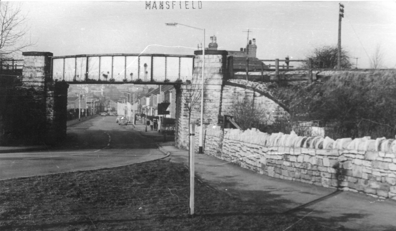
Photo 2 – is the bridge at the top of littleworth where it meets Forest Rd
By michael wilson (02/03/2012)
I agree with Angela, the first view looks as if it was taken from what would become Dame Flogan Street with 6 of the arch’s in view, a very early photo indeed. The railway bridge in No2 is indeed the Mansfield Southwell railway over Littleworth near the Fisher Lane junction and looking at a modern day picture I regret to tell you all, the young tree didn’t survive!
By Berisford Jones (01/03/2012)
In fact the more I look the more it seems to confirm that it is indeed Stockwell Gate from a position just a little way from Bancroft Lane. Looking at the photo can be seen a cycle leaning against a modern capped brick wall, this must be the new (at the time) toilet block that was situated at the junction. The pub a little further up was the King & Miller and a quick internet search (NCCW002711) will show the pub and its sign to confirm it. I’m quite surprised how narrow this part of Stockwell Gate was up until the late 50’s. The bus stands must have been elsewhere?
By Berisford Jones (29/02/2012)
Darren, I wonder if No4 is indeed Stockwell Gate but as Alan suggests, lower down than you suspect. The William IV public house sits at the top of the hill. The sign that can be seen hanging part way up the hill could well belong to a ‘Inn’ that is mapped just below Padley Hill. Also photo’s from the late 50’s that show the old Workhouse wall just before the summit confirm it was tiered differently to the one shown in the photo. So my vote goes with Alan, Stockwell Gate, looking west, pictured from the Bancroft Lane junction. Interesting picture though. It’s surprising how much of the town never seems to have been captured on film.
By Berisford Jones (29/02/2012)
Photograph One is the viaduct, taken from what would become Dame Flogan Street looking over White Hart Street towards the back of the White Hart and the Swan. Photograph Two is from the top of Littleworth looking down towards town (with Fisher Lane to the right behind the embankment). Photograph Four, I am fairly sure, is Stockwell Gate looking towards the Workhouse on the left and William IV on the right with the hanging sign. Photograph Three I have no idea – possibly part of Bath Mill…?
By Darren Turner (28/02/2012)
Photo 1 is the back of White Hart street, where Dame Flogan street is now. Photo 2 is looking down Littlworth from the junction with Forest road/Windsor road. Photo 3 I dont know Photo 4 looks like Stockwell Gate/Sutton road, looking up towards the old Victoria Hospital
By Angela Roche (28/02/2012)
Photograph 2….I believe is the bridge over Bath Lane. Going from Carr Bank towards the Grand Picture house..Barringers would have been down on the left before the bridge. Photograph 4…. Is the bottom of Sutton Rd. The Workhouse is on the left, and if my memory serves me right, it was called Padley’s Hill. Photograph 1…Has to be Quarry Lane Viaduct.
By alcurtis (28/02/2012)
Photograph 1…Is the Viaduct over the town, and not Quarry Lane. It is given away by the drain pipes which run down the bridge supports. I read somewhere it took 1000 men a year to build.


Comments about this page
I’ve often seen this ‘Pumping Engine’ shown on old maps, now we know!
photo no 3 is a old pumping station alongside the old mansfield to pinxton railway line.I dont know when it was last used but was behind houses on millersdale avenue , about half way along.New houses have been built on the site now and the pipes could have been a new drain being installed.
Photograph 2…Although quite similar, I agree that the bridge is at the top of Littleworth…. Photograph 4…I remember that I was pushing a wheelbarrow home along this road. which I had purchased from Hameyer and Copelands…When a Co-op Shire Horse, which had been spooked, bolted down Sutton Road at full gallop, complete with Dray and milk crates, but no driver. It flew past, and I have often wondered what happened to it, and how it came to a halt ! This was in the 1950’s. Alan
Alan, Berisford, you’re absolutely right on image 4. There’s a photograph on the Picture the Past (image number NCCW001834) that shows the same view from slightly closer into town showing clearly the Bancroft Lane sign.
Photo 2 – is the bridge at the top of littleworth where it meets Forest Rd
I agree with Angela, the first view looks as if it was taken from what would become Dame Flogan Street with 6 of the arch’s in view, a very early photo indeed. The railway bridge in No2 is indeed the Mansfield Southwell railway over Littleworth near the Fisher Lane junction and looking at a modern day picture I regret to tell you all, the young tree didn’t survive!
In fact the more I look the more it seems to confirm that it is indeed Stockwell Gate from a position just a little way from Bancroft Lane. Looking at the photo can be seen a cycle leaning against a modern capped brick wall, this must be the new (at the time) toilet block that was situated at the junction. The pub a little further up was the King & Miller and a quick internet search (NCCW002711) will show the pub and its sign to confirm it. I’m quite surprised how narrow this part of Stockwell Gate was up until the late 50’s. The bus stands must have been elsewhere?
Darren, I wonder if No4 is indeed Stockwell Gate but as Alan suggests, lower down than you suspect. The William IV public house sits at the top of the hill. The sign that can be seen hanging part way up the hill could well belong to a ‘Inn’ that is mapped just below Padley Hill. Also photo’s from the late 50’s that show the old Workhouse wall just before the summit confirm it was tiered differently to the one shown in the photo. So my vote goes with Alan, Stockwell Gate, looking west, pictured from the Bancroft Lane junction. Interesting picture though. It’s surprising how much of the town never seems to have been captured on film.
Photograph One is the viaduct, taken from what would become Dame Flogan Street looking over White Hart Street towards the back of the White Hart and the Swan. Photograph Two is from the top of Littleworth looking down towards town (with Fisher Lane to the right behind the embankment). Photograph Four, I am fairly sure, is Stockwell Gate looking towards the Workhouse on the left and William IV on the right with the hanging sign. Photograph Three I have no idea – possibly part of Bath Mill…?
Photo 1 is the back of White Hart street, where Dame Flogan street is now. Photo 2 is looking down Littlworth from the junction with Forest road/Windsor road. Photo 3 I dont know Photo 4 looks like Stockwell Gate/Sutton road, looking up towards the old Victoria Hospital
Photograph 2….I believe is the bridge over Bath Lane. Going from Carr Bank towards the Grand Picture house..Barringers would have been down on the left before the bridge. Photograph 4…. Is the bottom of Sutton Rd. The Workhouse is on the left, and if my memory serves me right, it was called Padley’s Hill. Photograph 1…Has to be Quarry Lane Viaduct.
Photograph 1…Is the Viaduct over the town, and not Quarry Lane. It is given away by the drain pipes which run down the bridge supports. I read somewhere it took 1000 men a year to build.
Add a comment about this page